地球上的特别突出地方
纳图特乔地质公园位于葡萄牙中部内陆地区,与西班牙接壤,面积4624km2。距离里斯本(葡萄牙首都)200km, 距离马德里(西班牙首都)350km, 伊比利亚半岛中心。2003年申请加入欧洲地质公园网络,2006年9月加入联合国教科文组织世界地质公园网络。
纳图特乔地区含有丰富的地质遗迹,从6亿年前深海的页岩到现在的平原。地质公园还有雄厚的与自然相连的历史、文化和人类遗产,从整体的可持续发展方式推动旅游全面发展。地质公园与市里和当地企业家深度合作,为当地经济和可持续发展培养创新协同效应(综合效益明显)。
地质公园以非常古老的风景为特征,例如5千万年近乎完美的准 平原梅塔,从那里开始剩余的山脉直冲云霄。例如阿巴拉契亚型石英岩波峰,代表着前奥陶纪瑞亚克海洋,古生物多样化和创新的摇篮,那里受三叶虫情绪控制(化石);华立西型花岗岩以群岛和不规则碎片形地貌的地垒型山脉抬升。
突出的地貌、古生物、地壳构造和矿业遗产由19个国家和国际相关的地质点组成,例如尼亚加西亚的足迹化石公园,罗马金矿,花岗岩形态。
地质保护是地质公园的主要目标之一。保护地质遗产对现代和下一代人意义重大。纳图特乔有几个受当地和国家法律保护的地区,提高人们在自然保护区内地质保护的意识。尼亚加西亚的足迹化石公园受市级法律保护,塔霍河国际自然公园和自然纪念碑结合保护区国家网络。
运用一些适用于学校课程的教育项目(www.geonaturescola.com),包括一年学校项目,从中学生和老师共同运用从课堂中学到的知识运用到实践中。一个目标是教育年轻人尊重和保护自然,在地质科学的很多不同科目中发展实践途径并与自然理解相结合是可能的。教育项目以地质科学专业指导为目标,根据项目的目标在不同的地质公园点实施,让学生能够看到地质点、自然保护区,认识到这些对我们行星的过去、现在和将来的重要性。
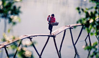
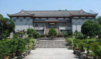
纳图特乔提供550km多短线和长线主题游线的步行网络,300km自行车游线,让游客在该区域内行走时发现地质公园的自然和文化。也可以享受塔霍河上乘船旅行和独木舟(皮划艇)。对于不爱冒险的人来说在地质遗迹点和历史景点的地质环路可以乘小型公车或自驾游。也有博物馆网络供游客发现亿万年的人类存在、岩石艺术、罗马城市以及类似的古文化。片岩村里有片岩商店,片岩和当地特产以古代形式呈现。以新的方式在地质餐馆和地质商店发现旧的口味是一种感官享受。也有以国家纪念点形式保护的历史村落,那里时代结束了,但是生命继续。一日结束时,纳图特乔地质公园当地独特的住房提供合适的住宿。
Geopark Naturtejo Meseta Meridional – Portugal
Highlights from a special place of Earth
Naturtejo Geopark is located in the inland, in the center of Portugal, near the border with Spain, and covers an area of 4624 km2. It is located 200 km from Lisbon and 350 km from Madrid, right in the middle of the Iberian Peninsula. The application to join the Global Geoparks Network started in 2003 and was successfully completed in September 2006.
Naturtejo territory is rich and diverse in Geological Heritage, starting some 600 million years ago, with widespread shales and turbidites deposited in deep sea, until nowadays’ plains and residual landforms. The Geopark also has an ancient historical, cultural and human component connected with nature for more than 150,000 years, promoting the integrated development of Geotourism. The Geopark is a strong partnership of municipalities and local entrepreneurs to develop innovative synergies in the local economy and sustainable development.
The Geopark's territory is characterized by very ancient landscapes, such as the 50 million years old “Meseta Meridional” peneplain from where residual reliefs rise up abruptly, as quartzite crests which represent the former Ordovician ocean cradle of paleobiological diversification and innovation; there are also granites cropping out as an inselbergs archipelago and as demi-horst mountains with peculiar minor landforms.
The outstanding geomorphological, geological, paleontological and ancient mining heritages are composed of 19 geomonuments with national and international relevance, such as the Ichnological Park of Penha Garcia, Portas do Ródão Natural Monument, Zêzere and Vale Mourão gorges, the Roman gold mine of Conhal do Arneiro and the granite landforms from Serra da Gardunha and Monsanto.
Geoconservation is one of the main aims of the Geopark. It is important to preserve Geological Heritage for our and future generations. Naturtejo has several areas protected by local and national laws, providing interpretation to raise awareness of the importance of Geoconservation within Nature Conservation. Ichnological Park of Penha Garcia, the Landscape of Gardunha Mountain and Conhal do Arneiro are protected under municipal laws and Portas de Rodão Natural Monument and International Tagus Nature Park integrates the National Network of Protected Areas.
Naturtejo Geopark Educational Programs are adapted to the Portuguese school curricula where students and teachers can apply together what they are learning in the classroom and find it in a natural context. One of our first aims is to raise the awareness of young people, and educate them to respect and conserve Nature. It is possible to have approaches in many different matters of Geosciences and integrate them in understanding Nature. The Educational Programs are targeted by specialized guides in geosciences for all the different teaching levels and run in different places of the Geopark depending on the teacher’s aims, allowing the students to know about the geomonuments and to understand that they are the key to the history of our planet.
Naturtejo Geopark offers a trekking network with more than 600 km of both short and long trails that invite tourists to discover the Geopark’s geodiversity and culture while they walk through the territory. Boat trips and geokayaking in Tagus and Zêzere rivers may also be enjoyed. 300km of mountain bike trails and 4 climbing areas, besides sky diving, are on offer for those who enjoy a challenge. Geocircuits by bus in the geomonuments are available for those less adventurous. There is also the museum network that enables the visitor to learn about archeology and local culture. Schist shops are available in the Schists Villages, places where schist and local products are preserved as in former times. New ways to find old tastes are a joy for the senses in geo-restaurants and geo-shops. There are also Historical Villages, national protected communities where the time has stopped, but life goes on in endless experiences.